BonaireTalk Discussion Group
Getting around Bonaire: Anyone know what this is?
Bonaire Talk: Getting around Bonaire: Archives: Archives 2007- 2008: Archives - 2007-06-01 to 2008-12-31: Anyone know what this is?
Top of pagePrevious messageNext messageBottom of page Link to this message  By Amy Johnson (BonaireTalker - Post #67) on Monday, December 1, 2008 - 4:30 pm:     Edit PostPrint Post

Hi all,

This is a photo from our recent visit to Washington-Slagbaai park. It is a cement block with "KAD-F 275" on it. We saw it at one of the dive sites on the northwest tip of the park, before Boka Slagbaai. I think it was at Wayaka, but I could be wrong.

Any ideas what it is, or what it's purpose is?

caption


Top of pagePrevious messageNext messageBottom of page Link to this message  By MadMan (Experienced BonaireTalker - Post #173) on Tuesday, December 2, 2008 - 6:14 am:     Edit PostPrint Post

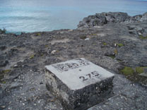
A mark from "Kadaster" don't know how to translate. They are the people that do the measuring of properties etc.


Top of pagePrevious messageNext messageBottom of page Link to this message  By Freddie (BonaireTalk Deity - Post #11121) on Tuesday, December 2, 2008 - 6:21 am:     Edit PostPrint Post

Surveyor...??


Top of pagePrevious messageNext messageBottom of page Link to this message  By MadMan (Experienced BonaireTalker - Post #174) on Tuesday, December 2, 2008 - 6:28 am:     Edit PostPrint Post

Thats the word. it is the government department that does the surveying. They have a few spots on Bonaire where they have a mark as a base from where the measure. They also use the black and white beacons you see on different spots on the island.


Top of pagePrevious messageNext messageBottom of page Link to this message  By Barry Gassert (Experienced BonaireTalker - Post #574) on Tuesday, December 2, 2008 - 7:02 am:     Edit PostPrint Post

There's even one at the top of Brandaris (sp). Care to go up and take a photo? :-)

It's quite an adventure but then you can see the mark...in cement...that someone had to hump up to the top.


Top of pagePrevious messageNext messageBottom of page Link to this message  By Amy Johnson (BonaireTalker - Post #68) on Tuesday, December 2, 2008 - 11:03 am:     Edit PostPrint Post

Cool. Thanks everyone.

Barry, I would love to get to the top of Brandaris one day. I'm sure the view is worth the effort!

Amy


Top of pagePrevious messageNext messageBottom of page Link to this message  By Bill Thorpe, (Experienced BonaireTalker - Post #367) on Wednesday, December 3, 2008 - 12:31 am:     Edit PostPrint Post

Amy
In the states, we Have the United States Public Land Survey System.

I live in the west and in soCal area there is a road called Baseline Rd, it's used for surveying-- we use it in Las Vegas.


Top of pagePrevious messageNext messageBottom of page Link to this message  By Kevin W. Williams (Bella Vista Estates) (Experienced BonaireTalker - Post #618) on Sunday, December 7, 2008 - 11:06 am:     Edit PostPrint Post

The kadaster's office is more than a surveyor. It also fulfills the functions that would be filled by the country registrar in the US: they keep track of the titles and deeds for each tract of land.


Visit: The Bonaire WebCams - Current Bonaire images and weather!
The Bonaire Insider - the latest tourism news about Bonaire
The Bonaire Information Site, InfoBonaire
Search Bonaire - Search top Bonaire Web sites


Topics Last Day Last Week Tree View    Getting Started Formatting Troubleshooting    New Messages Keyword Search Contact Moderators Edit Profile Administration